
by Doug Cunningham
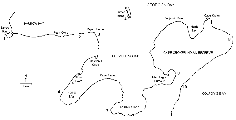
This section of the Bruce Peninsula offers sheltered paddling within Hope Bay and Sydney Bay and many opportunities to explore Escarpment geology along the Bruce Trail above these Bays. The total distance from Barrow Bay to the Cape Croker Indian Park is about 25 kilometres, if you follow the indented coastline of Hope Bay; or about 18 kilometres, if you avoid Hope Bay by crossing from Cape Dundas to Cape Paulett. In either case it is about one day’s paddling.
For more adventurous, experienced paddlers who enjoy longer crossings, there is a 2-3 kilometre side trip to Barrier Island. From the Cape Croker Park, it is another pleasant day’s paddle (winds permitting) from Sydney Bay around North Bay and Cape Croker, passing the Cape Croker Lighthouse to finish at the government dock on the south side of the reserve.
The main safety concern here is the exposed nature of the coast around Cape Dundas and Cape Croker. Winds from the north and east can cause considerable problems with breaking waves near the shoreline. During the spring paddling season there is potential for severe hypothermia in the event of a capsize. Dress accordingly. Poison Ivy is rampant along the shore.
The best time to make this trip is May through September. There is some cottage development at Barrow Bay, Jackson’s Cove and Rush Cove, and about 5 kilometres of cottage development at Hope Bay. Along the exposed coast between Barrow Bay and Cape Dundas there is little problem with boat traffic. Within Hope Bay and Sydney Bay during the summer months there is moderate boat traffic from small fishing boats to weekend sailors.
Camping is available at Cape Croker Indian Park and Hope Bay Campground. The boat launch at Little Lake in Barrow Bay and the Cape Croker Indian Park are ideal departure and finish points for this trip. Parking is available at both locations. There is also road access at Hope Bay.
POINTS OF INTEREST
(See Map)
- Water Falls: The boat launch at Little Lake in Barrow Bay is located next to a set of the waterfalls created when the waters of Judges Creek descend the escarpment. In spring, the falls can be quite spectacular.
- Greig’s Caves: These fascinating Algonquin Lake wave-action caves are located above the cobble shoreline about 0.5 kilometres inland at the base of the existing escarpment. If you wish to explore them, obtain permission from the owners; there is a nominal charge. These caves were used in the filming of Quest for Fire.
- Cape Dundas: Recently archaeologists have been probing this area for artifacts and structures connected to First Nation’s history.
- Barrier Island: This island (also known as Rabbit Island by the Ojibwa of Cape Croker) is located 2.5 kilometres northeast of Cape Dundas and has been given an ANSI classification. The island provides a habitat for nesting colonial waterbirds. Although cobble beaches are the main shoreline features there is a marshy area located to the south.
- Shoal Cove: A beautiful sheltered spot to stop for a picnic or lunch. As you paddle this northern shore you might notice the “Ridge and Valley” profiles running NW-SE which are believed to have been excavated by the retreating glaciers.
- Hope Bay Forest and Potholes: As you paddle within Hope Bay just past Shoal Cove you will pass beneath the northern high cliffs. These cliffs represent the southern extension of the Hope Bay Forest, which has been given an ANSI classification. This area has been chosen as a UNESCO Biosphere Reserve Ecological Monitoring Site and the students of the Bruce Peninsula District School and Wiarton High School will be doing the surveying of the plant community. Paddlers can camp at Cedarholme Private Campground and replenish supplies at the small store. A short hike north on the Bruce Trail will bring you to some of the best examples of Indian Potholes on the Bruce Peninsula.
- Cape Croker Park: This beautiful park at the base of Sydney Bluff is always given high marks by tourists and campers. It is owned and operated by the Cape Croker Ojibwa First Nation and is definitely worthy of a stay. The Cape’s high bluffs (Sydney, Jones and Kings) are bounded by sand and cobble beaches, which display past glacial episodes. The views of the Bay from the Bruce Trail lookout at Sydney Bluff are spectacular!
- MacGregor Harbour: This harbour has an access point that joins to a 1-kilometre long road which passes straight through the village of Cape Croker. This street may be used as a portage to reach the main boat launch area on the southern side of Cape Croker at the entrance to Colpoy’s Bay. This can be a useful route when the winds and waves make paddling the exposed north and east coasts dangerous.
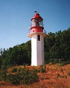
- Cape Croker Lighthouse: This light tower was the first on the Great Lakes to be constructed of reinforced concrete. At present, the tower and a bungalow built in 1958 remain.
- Cape Croker Government Dock: This boat launch area is a good place to end a trip around Cape Croker.
ADDITIONAL INFORMATION
Map: 1:50,000 Cape Croker (41 A/14)
Camping: Available at Cape Croker Indian Park (www.capecrokerpark.com 519-534-0571) and at Hope Bay Campground (www.hopebaycampground.com 519-534-1208).
This is one in a series of Bruce Peninsula paddling trip descriptions written by Doug Cunningham for the Georgian Bay Committee. It was originally published in the Autumn 2001 issue of Qayaq.