
by Doug Cunningham
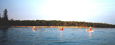
The somewhat protected waters of Stokes Bay and Myles Bay on the west side of the Bruce Peninsula provide an excellent area for a single-day loop-trip. The trip is approximately 12 kilometres in length and requires about 4 hours of leisurely paddling not including sightseeing stops or refreshment breaks.
Ten islands dot these two bays and the excursion is attractive to both experienced and novice kayakers alike. In addition to kayaking, the clear, warm waters provide excellent swimming, fishing, sailing, and snorkeling. Lyal Island, the Knife Islands, and Mad Reef provide a variety of paddling attractions from the remains of the Lyal Island Lighthouse through the tern, gull, and cormorant colonies of Mad Reef, to the picturesque lighthouse on the Northwest of the Knife Islands. In addition, the remains of a number of shipwrecks are visible: the Ripple located near Dane Island, the remains of the Goudreau a kilometre past the abandoned heronry on the southwest corner of Lyal Island, and the remains of a cement-hulled tugboat just north of the Lyal Island light. The exposed limestone pavement of these Islands’ shorelines, with their embedded Silurian fossils and pitted dolomite texture, provide a fascinating glimpse into a world almost 425 million years ago. The sunsets are spectacular and when wind/wave conditions permit it is worthwhile to time your trip to finish at the end of the day. Maybe you will be lucky enough to see the famous “green flash” which accompanies the last rays of the setting sun.
Wind and waves can make for hazardous paddling conditions on the West side of Lyal Island, Mad Reef, and Greenough Point. Pay attention to the weather. Poison ivy is prevalent and the Massassauga Rattlesnake is common on Lyal Island.
The best time to make this trip is May to September. There are cottages at Stokes Bay between the Stokes River and Tamarack Island, along Old Woman’s River to North Star Island, and along Look About Bay. During summer weekends it is common for there to be a number of fishing boats and jet skis active in this area but they are not a hazard to navigation and the traffic volume lacks the density that would detract from the quality of the paddling experience.
Sandy Beach on Myles Bay is a good departure point for this trip, and offers free parking. To reach Sandy Beach, turn west off Hwy #6 at the main intersection in Ferndale and proceed until you come to a stop sign. Turn right and continue north for about a kilometre and take the first left turn (before the bridge) and follow the dirt road west to the shores of Lake Huron. Continue on this road until you cross over Old Woman’s River Bridge and the make an immediate left turn and continue for a kilometre further to Sandy Beach.
POINTS OF INTEREST
View GLSKA Lyal Island in a larger map

- Sandy Beach: A popular swimming beach for the residents and tourists of Eastnor Township and the departure point.
- Black Creek Nature Reserve: The ponds and streams of this area provide a magnificent wetland habitat for ducks, geese, and herons.
- Dane Island: Also known as Lone Tree Island. Close to the eastern shore of Dane Island is the wreck of the tugboat Ripple which sank in 1905.
- Abandoned Heronry: Just a few years ago this southwest extension of Lyal Island was populated with more than 60 Great Blue Heron nests. Today the heronry is abandoned but the evidence of its former presence is readily observed in the dead trees and derelict nests. On a calm day this area is a nice spot to stop for lunch.
- Wreck of the Goudreau: To find this wreck you will have to paddle out into Lake Huron about one kilometre keeping the Southwest point of the Lyal Island heronry in line with the tip of McMaster Point and Black Point light. The Goudreau sank during a November blizzard in 1917.
- Limestone Pavement: On the Western parts of Lyal Island there are sections of exposed pitted limestone pavement.
- Lyal Island Navigation Light: A fascinating place to explore! Take care not to contact the poison ivy but search for the remains of the old lighthouse and lighthouse keeper’s house. Explore the exposed beach for numerous Silurian fossils or simply climb to the top of the automated navigation light for a fine view of the Western shore of Lyal Island. A pleasant place to stop for lunch or supper and a refreshing swim.
- Cement-Hulled Wreck: An interesting wreck of a cement-hulled tugboat is located just north of the Lyal Island navigation light at the shoreline.
- Mad Reef: During late spring this low-lying island and reef complex is home to many nesting gulls and terns. Take great care not to disturb these nesting sites.
- Greenough Point: Sometimes westerly winds will produce plunging waves over the ledge just west of Greenough Point and these conditions will make for challenging paddling. During an 1883 November storm the barge Iowa struck this ledge and sank.
- Knife Islands Lighthouse: The lighthouse is located on the northwestern end of the largest of the Knife islands. Paddling between these islands and in front of the Lighthouse will provide opportunities for kayak photography.
- Black Point Light: This navigation light is located at the southeastern entrance to a narrow inlet called Irish Harbour.
ADDITIONAL INFORMATION
Map: 1: 50,000 Cape Croker (41A/14)
This is one in a series of trip descriptions collected by the Georgian Bay Committee for a paddling guide to the Bay.