
by Brian Rohde
Everything Ron and Nancy promised in their GLSKA trip listing happened over the nine-day trip. We had plenty of fog, big seas, lots of surf landings and launches and some long days on the water. To say the least, it was quite an adventure!
The six of us met at Naturally Superior, an outfitter near Wawa at 4 p.m. after an eight-hour, 700-kilometre drive from Parry Sound. Standing in the rain looking at the confluence of the Michipicoten River and Lake Superior was intimidating as the standing waves were 3-6 feet and we had to pass through them to get into the Lake the next morning. Water temperatures were reported to be in the range of 4-7 °C. The owner of Naturally Superior, Dave Wells, said the waves would likely be down the next morning as the flow was controlled by the hydro needs. He also said the waves looked much bigger when paddling in them.
That evening Dave treated us to an interesting slide show to acquaint us with Lake Superior and the area we were going to paddle. He included a geologic history, aboriginal culture, flora and fauna and many beautiful pictures of what was in store for us. I left to sleep in my car feeling excitement and trepidation about what was to come.
This was to be my first trip. I’ve paddled on Georgian Bay for 10 years and attended instructional weekends with GLSKA but never been on a 10-day trip. Even though I had loaded my gear into my kayak a couple of times before coming I wasn’t sure how all the stuff I’d added would fit. Nancy had been very helpful in suggesting food to bring (thank God as I would have quickly tired of minute rice and tuna) and Ron had suggested clothing and gear that I’m glad I took along.
Ron Coulson was the organizer; his wife, Nancy was the only women in the group of six. I knew them from a GLSKA rolling weekend I attended in 2006. Dave Foss was another who had been at the same weekend at the McCoy’s. Bill Jackson and Dan Crocker were the other two members of the team, and I had just met both of them. Ron, Nancy and Bill had paddled a similar route in 2005. Lake Superior was a new experience for the other three of us.
On a grey overcast day at 8 a.m. we exited the Michipicoten River where, true to Dave’s word, the waves were down and with a following breeze we paddled 25 kilometres to our first campsite near the Dog River.
Dave, Bill, Dan and I opted to paddle up the Dog River to a trail at a portage point that led to Dennison Falls, a 200 foot high series of falls that were quite spectacular. At this time of year the flow would normally have been far less, but due to recent heavy rain the streams and rivers were at springtime levels. We had good views of the falls but after an hour of bushwhacking in steep and nearly impenetrable forest to find the portage trail to the top we gave up and returned to our campsite.
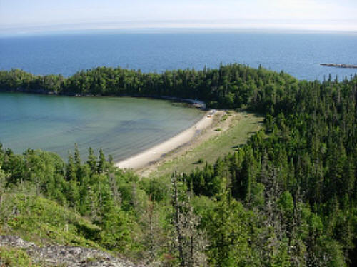
This section of Lake Superior is a spectacular coastline. Sheer cliffs hundreds of feet high drop to the water’s edge where enormous boulders line the shore. Streams and rivers empty into the lake with the occasional waterfall. There are crescent beaches of cobblestone and others of sand, some well protected and others exposed to the fury of the ocean-like seas. The land is mostly forested with a boreal makeup of spruce, fir, birch, quaking aspen and mountain ash (which was flowering). There are numerous flowers including wild rose and lady’s slipper, all tenaciously hanging on in this harsh environment.
Our second day on the water took us past Pt. Isacor, infamous for the 8 kilometre stretch of cliffs without any takeout points. We paddled offshore a ways to avoid the confusion of the reflective waves. I was relieved when we rounded the point and stopped for a rest at the first beach. Ron and Nancy like to stop every couple of hours if possible for a stretch and a bite to eat. It was sunny and pleasant but we soon had to get on the water to get to the campsite at Le Petite Mort. It wasn’t until a couple of hours later Ron realized he had left his VHF marine radio and one of his water bottles at the rest stop. It was too far back to go so he planned to pick it up on the way back. We logged 35 kilometres and set up camp on a sandy beach.
The 160 kilometres of coastline from Michipicoten to Hattie Cove in Pukaskwa National Park has no commercial facilities. You are virtually on your own and even emergency help is difficult as it takes two days for the Coast Guard to get to the area by boat. We started with two handheld marine radios but were down to one and the battery power was limited so we had to conserve for emergency use. We only saw three yachts in the distance during our first seven days. It is a very remote area.
That night we had heavy rain and thunderstorms as the forecast weather came through our area. I was barely awake and cosily lounging in my warm sleeping bag when at 5:45 a.m. I was abruptly flooded by a large wave that swept sand and water through my tent soaking my sleeping bag and other gear. What a rude awakening! I scrambled out and gathered my gear to higher ground. The weather had changed and that was to be the start of new paddling experiences.
We all “seal launched” to get through the breaking waves only to encounter 2-3 metre waves farther offshore. The quartering waves were intimidating at first until I felt more comfortable running down the front of them. We were in fog but the wind had diminished considerably. Our first rest break required a surf landing; with Dan and Ron to help, we all made it successfully. We became much more comfortable with surf landings and launching as the trip progressed.
While we were enjoying a rest break the fog lifted and the breeze came out of the southwest. Soon after we launched it strengthened to 20-25 knots causing confused sea conditions as the early waves had been from the east. Although the waves were smaller we struggled against the wind on the nose and dealt with some breaking waves as well. Our next rest stop, on an unnamed and steep cobble beach, was welcome relief and we spent a couple of hours resting and getting warm before departing using our seal launch technique.
Fortunately the wind had diminished and the seas were calmer but I was ready to make camp when we rounded a point and got into the lee on our way into Bonamie Cove. There was a lovely cobble beach with cliffs on each side and several terraces of cobble to set up tents and store the kayaks safe from the surf. Dave fell into the drink getting out but we had the perfect afternoon for drying out and enjoying the protected beach with its western exposure. We had only made 22 kilometres that day; the distance didn’t represent the effort we had put in and the tobacco offering Nancy made to Michipeshu (the Great Lynx) had not yet worked its magic and appeased the deep waters.
Ron likes to get an early start and settle in camp by 2 or 3 in the afternoon so that we can enjoy the campsite and lounge, explore or fish. Afternoon tea became a ritual we looked forward to.
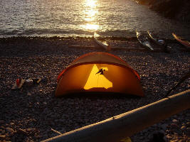
Much to my surprise, we all preferred camping on small cobble beaches to sand or grass. With a mattress pad it is amazing how comfortable the cobbles are and what a good night’s sleep one gets. Sand gets into everything and grass is usually accompanied with a lot more flies. There was talk of how great the gentle sloping rocks on Georgian Bay are for getting in and out and how nice the campsites are on flat rocks, a choice we didn’t have on Lake Superior.
Dan, Dave and I explored the cliff above and went through the forest with its incredibly deep, wet and spongy moss to the beach nearby. It had many more levels of terraced cobble going back hundred of feet and at its highest was probably 60-80 feet above the lake. On the highest level we found Pukaskwa pits that are found in many places around Superior. These depressions in the cobble are clearly not made by natural causes and there are numerous explanations of their use for aboriginals dating back from 1000 BC to 1500 AD. With the isostatic rebound of 15 m / 1000 years that is thought to have occurred after the retreat of the glaciers, these pits would have been made close to the lakes level at the time. Quite amazing to witness such a vast change in such a short time – at least in the geologic time scale!
Sitting around the fire that evening with the glow of the late day sun we were comfortable and confident about the following day when we only have 14 kilometres to get to our final destination at Cascade Falls. That and the beautiful sunset were not to be. A cloud bank obscured the setting sun, a harbinger of the weather of the next day.
We awoke to a low overcast, strong southwest winds and rain. Whitecaps were everywhere and breaking seas and 2-metre waves were visible from our “protected” cove. The waves were breaking on the beach moving around the cobbles with a somewhat menacing sound of the power of the surf. Again we moved the kayaks to higher ground and hunkered down in our tents and sleeping bags to make the best of a cold and dreary day. The wind and surf intensified throughout the morning and the noise of the cobbles rolling around would wake me. Occasionally I looked out the little window in the tent and then fell back to sleep. A large wave washed into my tent and soaked all my stuff again and I scrambled out to get to higher ground, dragging all my wet stuff with me. The kayaks had moved and Ron and Nancy’s tent was flooded as well. Dave had moved to a higher shelf earlier and Nancy had voiced her concerns to Ron who assured her we were okay and not to worry. By then we knew we were unlikely to leave that day, so we spent the day coping with the adverse conditions.
Bill and Dan (in their wetsuits) and Dave were huddled under a tarp next to the cliff where they had a little shelter from the wind and kept a fire going for the little warmth they could get. Ron, Nancy and I climbed the rocks and found a sheltered spot perfect for staying out of the wind and brewing a large pot of tea. Bill later joined us and the four of us were warm and refreshed after a couple of hours. We began to see a few openings in the clouds and some blue sky and talked about the possibility of setting off that evening; but after checking the weather forecast on Dan’s radio which called for strong wind warnings (20-30 knots), we decided to stay put until the next morning and get an early start.
Monday brought clear skies and cold temperatures but the wind and waves were down and we all wanted to move on. The previous evening we had prepared a launching ramp of driftwood logs and boards to seal launch on the very steep cobble beach, but it was calm enough to launch parallel to beach. We were on our way at 6:15 with plans to have breakfast at Cascade Falls.
On the way, Dan (who usually led the pack) was falling behind and he and Ron thought he was taking on water. He continued until we got in the lee of an island where he could land. It turned out to have been his sponson bag which had come unlashed from the rear deck and was over the side dragging underneath the boat. It was easy to fix. The remaining 5 kilometres was in the protection of Otter Island and we were at the falls by 9:45.
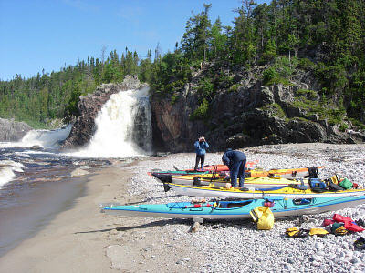
The falls were spectacular with a torrent of water dropping a couple of hundred feet in several levels, the last emptying directly into the lake. There was much more water than there had been a couple of years ago and the mist spread across the beach which was strewn with debris, making finding suitable spots for our tents difficult. The forecast was for the northwest winds to build throughout the day coming directly onto the beach. Not wanting to have our tents flooded or being forced to spend another day on a beach we opted to head back to the south end of Otter Island where we had passed a well protected, cobble, multi-tiered beach earlier that morning.
I heard stories of bathing in pools of relatively warm water in the falls but as I climbed up along them I found it hard to imagine because of the high volume of cold water coming down. After a snack, some exploration and a pleasant rest we proceeded back to one of our best campsites of the trip arriving early in the afternoon.
It was a beautiful day and we swam (a bit of an exaggeration since the water was frigid – 7o C – and it was really a plunge in and a dash out) and explored the island which had high cliffs that gave 360o views. There were caribou signs about the forest and skeletal remains on the beach that we assumed were the same. Dan discovered a radio tracking collar next to the skull which he took with him to turn in to the appropriate MNR office. We had our customary fire after diner to help keep the mosquitoes away and take care of our trash.
With a 7:30 start we paddled into southerly winds and small waves. Ron went ahead to recover the foam pads for supporting his kayak that been mistakenly left on our trip out. The wind was on our nose blowing 15-20 knots with whitecaps and waves that slowed our forward progress and made paddling difficult for some of us. After we took a long lunch stop the wind subsided and the fog rolled in.
We stayed fairly close to shore as the waves had flattened. The shoreline was especially beautiful in these conditions as it came in and out of view. We’d head out occasionally when surf was breaking offshore. As we tucked in behind Crane Island to our destination we came out of the fog and entered a completely protected cove with shallow water and picture perfect crescent sand beach. Aside from the sand and flies it was a perfect campsite. Large and fresh moose prints indicated we were invading someone else’s ground.
Awakened at 5:30 by Ron to get ready for an early start, we found that conditions had changed once again. We left at 7 a.m. and headed out into a thick fog; my glasses were covered with moisture, restricting visibility. Again the wind was calm as it usually is in fog. We were all cold, especially Dave whose wetsuit had been soaking wet. After two hours we rafted together to stretch and have a snack, foregoing the usual break on dry land every couple of hours. With another 1 ½ hours of paddling we put into Floating Heart Bay for a much needed stretch, rest and lunch. We warmed up in the sun in the lee of some rocks, and it was difficult to find the motivation to get going again.
Underway, the fog continued to lift as we headed for the beach just before Pt. Isacor where Ron hoped to recover his VHF radio and water bottle. They were where he had left them and the radio was no worse for wear having been through several days of heavy rain. We had covered 32 kilometres by then, but decided to continue because of the favourable weather and the unfavourable forecast for the following day. With calm seas we stayed close to the high cliffs along the 7-kilometre section that we wanted to get behind us.
Dan went ahead to find a good campsite and the rest of us followed drawing on our reserves to complete the 45 kilometres. It was a small cobble beach just to the east of the Dog River. Our arrival at 5 p.m. gave us ten hours on the water with two breaks on land. Boy was I beat! And everyone else as well.
After a very leisurely breakfast we departed at 9 a.m. into a flat calm and sunny day. Since we only had 15 kilometres to get to our day’s destination at Minnekona Point we paddled close to shore enabling us to explore the coves and see the many streams and waterfalls emptying into the lake. The campsite at Minnekona was mostly sand with a couple of tent sites in the woods and a thunderbox.
We were enjoying lunch and tea on the rocks when two young fellows, Karl and Dave, paddled into the cove and joined us for lunch. They are on their 51st day of circumnavigating Lake Superior counter clockwise, having started at Thunder Bay on May 28. They expected to be home by the end of July making the entire 2200 kilometre trip in just over 60 days. (For more about their trip, see www.bigwater08.com.)
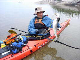 Fog set in while we were visiting with Dave and Karl and lasted throughout the day. We mostly lounged around and took naps on the rocks enjoying an unusually inactive day except for Dan who persisted in fishing. He was rewarded in the evening when from his kayak he landed a six pound lake trout and lost another alongside. It was quickly filleted and fried and shared by almost all. (Bill had retired to his tent and nobody wanted to disturb his rest so we ate his portion.)
 With anticipation of getting home we departed at 7 a.m. in light fog and no wind arriving at the outfitter about 9:30. Just before paddling into the Michipicoten River we gathered together and acknowledged the wonderful and adventurous week we had shared. Old friendships grew and new friendships had been made. Nancy’s offering of the previous week had worked; Michipeshu had granted us a safe journey.
For over a week we hadn’t encountered another person. This area of Superior is remote and beautiful. The water is dangerously cold and the lake is changeable quickly. It was an adventure of a lifetime.