
by Šárka Lhoták
 Sarka Lhotak
As we drove through Sibley Park, a wolf crossed the narrow road right in front of our car. Wow! This must be a good omen; it would be a great trip!
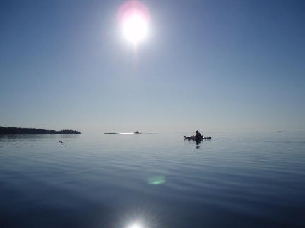
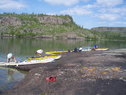
There were seven of us: Sam with his wife Sonja, John, Bill, Laura, May and me. In the village of Silver Islet we quickly packed all the stuff into our kayaks, gave car keys to the three drivers that David Tamblyn, the owner of Superior Outfitters, had arranged for us. They would take the cars back to Rossport where we expected to arrive in 8 days. We launched around noon, travelling northeast along the shore to Middlebrun Point. From there we crossed to Porphyry Island, an 8-kilometre crossing with little Gravel Island in the middle. As John told us, Gravel Island is a spawning site for all the herring in Lake Superior, and John wanted to have a look at it. (John is a marine biologist who works in the Canada Centre for Inland Waters; the Great Lakes are not only his recreational playground but also his workplace). There was some headwind on the crossing; it was sunny with a little chop.
We arrived at Porphyry Island without a hitch and set up camp on the grassy opening at the dock. Two motorboats were tied up there. May put her tent up right on the dock so that she could dive in straight from her tent. We ran the one-kilometre road through the bush to the lighthouse, as running was the only way to avoid hordes of mosquitoes. The lighthouse is automated; the keeper’s house seemed to have been only recently abandoned. The Porphyry Point is a spectacular black rock with bluebells and orange lichen; far away on the horizon we could make Isle Royal. After dinner we took a short walk across the narrow part of the island to the east side where there was a nice beach with black sand.
Day 2:
This was an ambitious expedition so we got up at 6:00 and launched by 8:00. Our destination today was Swede Island, some 25 kilometres away, where Sam promised a sauna. This area was settled in the past by Scandinavian loggers and fishermen who built saunas on the shores. Some are still standing, maintained by boaters. It was a nice sunny day and an easy paddling with several 2- and 3-kilometre crossings.
We arrived at Swede Island in the early afternoon and set up camp on a gravel bar near the sauna. The sauna was just a tiny little log cabin with a woodstove. Next to it was a cabin to be used in emergency, complete with a sign “Mining claim # 926182”. It was like something from Jack London. May started a fire in the woodstove and soon we were all there enjoying the heat in the sauna and a cold swim afterwards.
Day 3:
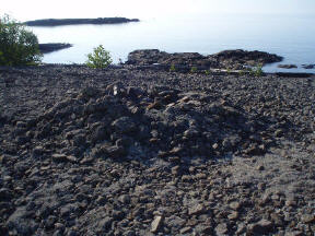
We got up before sunrise and by 8:00 we were already paddling on glassy water towards Loon Harbour. To our left was a magnificent rocky beach with a number of terraces so typical of Lake Superior. These terraces were created over hundreds or thousands of years by changing water levels. This one faced south. We landed to explore and found what we hoped for: a Pukaskwa Pit. These are round structures about two metres in diameter with a pit in the middle. They are said to be between 1,000 and 6,000 years old, built by Indians for spiritual purposes. Around lunchtime we were nearing Shesheeb Point. A note on my map said: amethysts. It was a good lunch stop, smooth black rock with a gentle incline for easy landing, majestic cliffs across the bay. But where were the amethysts? Very soon we found them and there were hundreds! In the black basalt rock they were lodged as round hollow stones with crystals inside, some white, others pink or purple. We took lots of pictures, had a good swim and finished lunch with wild red currants. The taste was more like a black currants with a touch of a skunky taste – but we enjoyed it nonetheless, at least us “Europeans” and May, always anxious to try anything and everything.
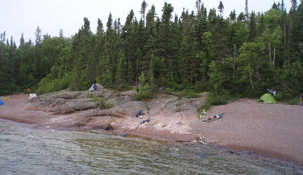
On our maps Agate Cove was marked as a campsite (from reports of other kayakers). However, we did not like it much and continued around Agate Point. Soon after, we came upon the nicest campsite – 9.9 on Sam’s scale of 1 to 10. A small cove, open to the east, with two gravel beaches and a nice smooth rock, almost Georgian-Bay-like, in the middle for a kitchen. There was great swimming and an amazing view.
Looking at the map we realized that we’d already paddled a big chunk of our trip and there was no need to rush. To our delight Sam declared that tomorrow we could sleep in – the launch was at 9:00!
Day 4:
Listening to my VHF, the weather did not sound good. Rain, wind, waves 1-2 metres, higher near thunderstorms. However, we packed up and left by 9:00. It soon started to rain and then poured. The wind was picking up and we decided to tuck behind the Fluor Island. This would make our route considerably longer but we would not have to fight the wind. There was no lunch stop; just a quick pee break. We were wet and cold. When we got into Blind Channel we were met by strong headwinds. Today we were heading to the famous CPR Spit on St. Ignace Island. It is famous for its well maintained sauna, a safe harbour and the scenery. The camp is maintained by The Friends of Squaw Bay.
To get there, however, we had to conquer few kilometres of exposed shoreline and round Newash Point. Here, the fetch is some 500 kilometres across Lake Superior. The waves were big and on top of that we were paddling in huge downpours – but luckily no lightning. There was nowhere to land now since the shore was being pounded by a mighty surf. We carefully navigated the waves well offshore. At Newash Point there was a row of shoals extending far out into the lake and kicking up white surf and spray everywhere. There was no safe passage through the white stuff, so we paddled out into the lake to get around it. Once past these shoals we turned back to shore and surfed swiftly to the safe refuge of Squaw Bay, also called The Hook or CPR Spit. We had the sauna to look forward to and a day of rest since we were staying here for two nights. The harbour was full; there were two big motorboats and a sailboat tied at the dock, hiding away from the big seas. The fire was on in the sauna. We paddled a little bit back and set up camp on a nice gravel bar.
After changing into dry clothes, we cooked soups and hot meals, and some of us headed for the sauna. I was happy to be dry after the cold wet day and had a snooze instead. Laura confessed that she was uneasy in the waves to the point that her knuckles were white from the death grip on her paddle. (The saying “white-knuckled” must have been started by kayakers!) Bill pulled out his fishing rod and in no time caught a big lake trout! Sam tried it too, and soon he had another fish, a speckled trout this time. Bill expertly filleted both fish, prepared them with sesame oil and seeds, wrapped in foil and carried them over to the dock area were there was a firepit with a grill. We chatted there with the boaters, them complaining how poorly visible our kayaks are and that they call us sea-fleas or sea-lice! We were somewhat offended by that. They regained some respect for us when told that some of our kayaks were 19 feet long. (Size matters.) The fish were awesome!
Day 5:
A layover day. We had a slow morning, a sauna session, washing and shampooing, and nice long swims after the sauna. Some of us hiked to the cliffs above the CPR Spit which gave us a great view of the shoreline we had paddled and the one that was still awaiting us. And somehow that day the expedition morphed into a relaxed holiday trip – and nobody minded at all, we were enjoying every minute of it.
Day 6:
We launched at a comfortable 9:00, and paddled past some nice islands, including Bowman Island with big gravel beaches and potential campsites. By noon we were at McNab Harbour and since we did not like it much as a campsite and it was still early we paddled on to Woodbine Harbour, which had been highly recommended to us by the boaters. However, what the boaters like is not necessarily good for us. It was a sheltered harbour alright, but the bush extended all the way to the water and there was not much camping at all. I missed out and was left with a crappy spot in a dense mosquito-infested bush. I bitched and complained that this campsite must score zero on the scale of 1 to 10. But we had a good swim there and Bill caught a trout so we had a good dinner and a campfire, too.
Day 7:
Our plan was to paddle to Battle Island and stay there for the last two nights. We paddled along Simpson Island. The shore was spectacular: black basalt hexagonal columns, remains of the volcanic history of this place. Less then 6 kilometres from our ugly campsite we found a cove with countless terraces guarded at the entrance by high cliffs, a spectacular, magnificent place. We landed and debated whether to stay here for the night. But eventually we paddled on for a couple more kilometres. There were countless coves with gravel beaches along this shore. Instead of paddling to Battle Island we set up camp, after only 7 kilometres of paddling, in a very nice bay which had a spot for each of us. For me there was a high terrace with a view, John and Laura preferred fine gravel, whereas Bill, May, Sam and Sonja opted for a sandy spot. We spent the rest of the day exploring this wonderful shore with spectacular beaches, volcanic features, amethysts and agates, and swimming, of course.
Day 8:
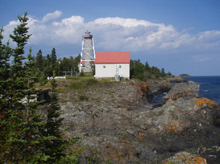
 We now had less than 8 kilometres to Battle Island. Battle Island has a tall lighthouse on its southwest point. We hoped to convince the lighthouse keeper who is now retired (the lighthouse fully automated) and spends his summers there, to give us a tour. For this purpose Sam carried a little present in the form of a bottle all the way from Silver Islet! We landed on the north shore of the island where there is a sheltered cove with a dock. Two kayaks were already parked there. Their owners soon returned, disappointed that the old guy was in grumpy mood and wouldn’t show them around. Let’s try our luck. We found him sitting on the porch; he barely returned our greetings and would not talk to us. A sign on the lighthouse read “Danger, No Entry” and the door was barred. We kept walking on to the shore while Sonja stayed back and managed to get the old man talking and eventually offered him the gift. Soon we were climbing the narrow stairs up on the lighthouse! There we saw the big turning mirrors and surprisingly small light bulbs, walked along the windy catwalk and listened to the lighthouse keeper’s stories. He was trapped there in the big storm of 1976 when the waves broke windows on the 120-foot lighthouse and in the keeper’s house as well.
Day 9:
 Our trip was over. An early launch, a short paddle to Rossport, pack the cars and the long drive home. What a wonderful holiday. The map is full of notes; I will be back for sure. Thank you, Sam for organizing and leading this amazing trip.
Additional Info
Maps
52 A/7
52 A/8
52 A/9
42 D/12
42 D/13
Charts