
by Doug Cunningham
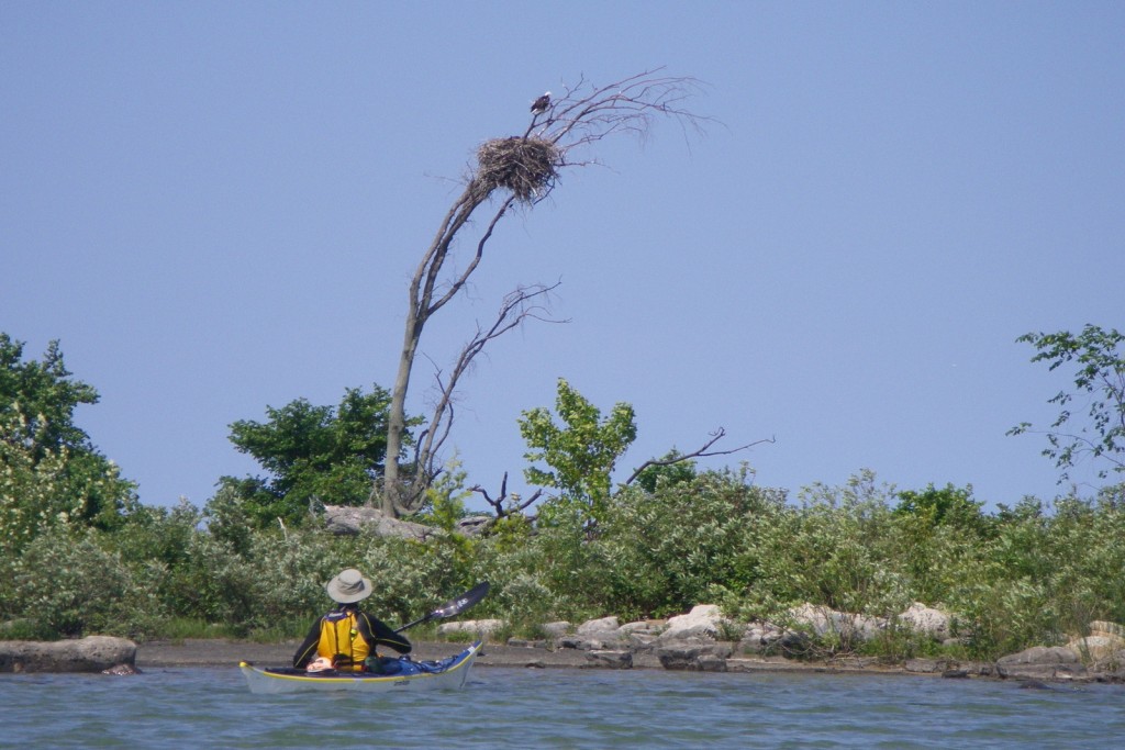
- Eagle’s nest in the Fishing Islands.
Imagine exploring an archipelago of over 70 dolomite islands located no more than 3 kilometres from the western shoreline of the Bruce Peninsula. The Fishing Islands offer just such an experience. The trip through the islands from Oliphant to Red Bay or Howdenvale can vary in length from 11 to 15 kilometres depending on the number of islands explored. This trip is usually done as a day trip but it may also be combined with other sections along the Bruce Peninsula to become one leg of an extended trip.
The Fishing Islands get their name from the lucrative fishery that was supported in the early 1800s. Indeed, the schools of herring, whitefish, and lake trout were so thick that it is reported they lifted each other out of the water. However, by 1850, the vast schools of fish had been all but decimated.
The area is rich in history and folklore and the local names of many of the islands reflect their past and legends. Main Station Island was the location of Captain Alexander MacGregor’s fish plant, built in 1834. Whiskey Island was where MacGregor’s men went to enjoy themselves, while Smokehouse Island was used by the Ojibway to cure their fish. The Rowdies take their name from two wild fishermen brothers. Campers found a body jammed into a fissure on Deadman’s Island, and Scotch Bonnet was said to look like a highlander’s headgear. The many rocks and reefs have claimed numerous ships over the years, including the brig Philo Scoville, the Blanche Shelby, the tug Phoenix, the schooner Sarah, the Oxford, the Gold Hunter and the Jennie Rumball.
The Fishing Islands, and their surrounding shallow, warm waters, provide paddling enjoyment on many levels. Some of the islands are no larger than the exposed top of a shoal and others, like Cranberry Island, are upwards of 100 acres in area. The waters are so clear that, from the seat of a kayak, one has the illusion of flying over the dolomite lake bottom. The route takes one past the Oliphant Fen, a naturalist’s delight; there are numerous bird nesting colonies on the outer islands; and a number of shipwrecks await discovery. In addition, the waters provide excellent sailing, wind surfing, swimming, snorkeling, and yes, fishing for rainbow, perch, lake trout, salmon, and bass, depending on location.
The Fishing Islands provide sheltered waters and a natural buffer against Lake Huron’s westerly winds and waves, however caution should still be exercised when paddling along the west sides of these Islands. Not all of the islands or shoals are plotted on a topographic map so pay attention when you are paddling. Poison ivy is prevalent on the outer islands.
The best time to make this trip is May through September. There is cottage and shoreline development at Oliphant, Little Red Bay, Red Bay, Howdenvale, and isolated cottages on many of the Fishing Islands. Note that most of the islands are privately owned or belong to the Saugeen/Cape Croker First Nation. Camping is not permitted, but stopping on the outer islands for a picnic lunch is rarely a problem. During the late spring and summer weekends there is considerable boat traffic within the Smokehouse Channel leading to and from the Oliphant Government Dock and, during summer weekends, there are scheduled sailboat races in the protected waters of Red Bay. However, the boat traffic is not of sufficient volume to detract from the kayaking experience.
A good starting point for a trip through the Fishing Islands is the government dock in Oliphant. The trip can be completed either at the public wharf beside the Red Bay Community Park or at the Howdenvale government dock, two kilometres farther north. Parking is available in Oliphant, Red Bay, and Howdenvale, as well as at Petrel Point, between Red Bay and Howdenvale.
POINTS OF INTEREST

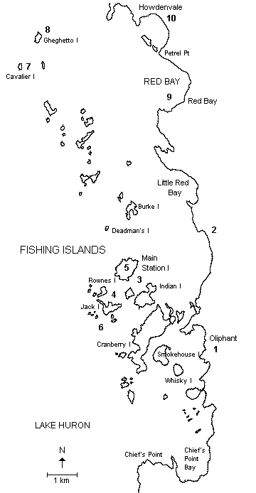
- Oliphant Government Dock: A good location to begin your kayak exploration. Follow the Smokehouse Channel between Smokehouse Island and Whiskey Island and, if weather conditions permit continue west and north between Vimy and Cranberry Islands to gain access to the Fishing Islands beyond Indian Channel. The marshes between Cranberry Island and the mainland are difficult to travel through during periods of low water levels.
- Oliphant Fen: Between Chief’s Point and Red Bay is the Oliphant Fen, a naturalist’s delight. At 8 kilometres in length it is the largest alkaline fen on the Great Lakes. Varying in width from 20 to 500 metres this fen meadow receives waters rich in calcium, magnesium, and alkalinity from the eastern part of the Bruce Peninsula. This fen showcases rare orchids such as the ram’s head orchid, special flowers, such as the indian plantain and the insectivorous pitcher plant and sundew. It provides a home to unique amphibians like the red spotted newt, which spends its larval stage on land and its adult stage in the water, and the abundant bird fauna. Twenty species of warblers, 10 species of ducks, and 8 species of hawks provide entertainment for the birders during the spring and fall migrations. It is not uncommon to hear the whistling of the tail feathers of the common snipe as it dives above the dwarf cedar and tamarack forest bordering the fen.
- Wreck of the Tug Phoenix: During a storm in 1901 the tug Phoenix was stranded and broken apart by ice. Pieces of her hull are lodged in the sand between Main Station Island and Indian Island.
- Wreck of the Scoville: The brig Scoville went down in late October 1853, downbound from Milwaukee to Buffalo, carrying 13,000 bushels of wheat. Her wreckage lies in the shallow passage between Scotch Bonnet (Rownes Island) and Jack Island.
- Remains of MacGregor’s Fort: Captain Alexander MacGregor built a solid stone structure on Main Station Island in 1834 to support his thriving fishing business. Its dimensions measured 57 feet by 18 feet and became known as the “fort.” The remains are still visible today.
- Limestone Pavement, Grikes and Glacial Striae: On the Western exposures of Jack Island, Rownes Island, Indian Island, and Cranberry Island are the long grooves or glacial striae left behind by a retreating glacier 10,000 years ago. These grooves have been widened by solution weathering and now form grikes, or solution fissures. As well, the limestone pavement is frequently pitted, again the product of chemical weathering.
- Cormorant Nesting Area: Cormorants will sometimes nest on the eastern side of Cavalier Island.
- Heronry: On the southern end of Ghegheto Island there is an extensive great blue heronry; sometimes as many as 60 nests are occupied.
- Red Bay: This beautiful, sheltered bay provides numerous recreational opportunities for residents and guests alike. The name is derived from “Red Stone Bay” which referred to a large red boulder that stood on the shore. Native legend has it that this bay was the site of a major battle between the Council of Three Fires (Ojibwa, Ottawa, Potawatami) and the Iroquois. The Bay was said to have run red with the blood of the defeated Iroquois. The public dock provides an alternate end point to the trip if you don’t continue on to Ghegheto Island.
- Howdenvale: Trip end at the government dock.
Type: Day
Class: B-2
Launch: Red Bay
Length: 15-20km
Parking: Oliphant, Red Bay, and Howdenvale, as well as at Petrel Point, between Red Bay and Howdenvale.
Maps: 1:50,000 Cape Croker (41 A/14); Wiarton (41 A/11) (Note: The topographic maps do not show all the islands.)
Chart: Canadian Hydrographic Service Chart 2292 (Chantry Island to Cove Island)
This is one in a series of trip descriptions collected by the Georgian Bay Committee for a paddling guide to the Bay.
Except for a small portion of Beaumont Island, all of the other Fishing Islands, including the outer islands, are privately owned. The owners enjoy their privacy and do not appreciate trespassers, so it is advised to stay off the islands.
Interesting read. Thanks for sharing.
Beament island at Red Bay is a nature reserve and accessible to the public. A great place for a swim in the protected sandy harbour and picnic on the outer lake side.